


Stowe-Area Hiking: Bingham Falls from Route 108
Hike Details
- Skill Level: Moderate
- View Trail Map
- Type: Waterfall hike
- Distance: 0.5 miles
- Time: 30 – 60 minutes
- Climb: 200’
- Trailhead Location: 6524-6892, Mountain Rd, Stowe, VT 05672. From the historic village, take Route 108 north 6.4 miles. About a half-mile after Stowe Vacation Rentals and the base of the Auto Toll Road, park in one of the dirt pull-offs located on both sides of the road. The trailhead is on the east side (on the right as you are driving up). Be mindful of all posted parking signs and only park in areas designated for parking. Be careful crossing the street and getting ready for your hike in these parking areas, as this section of Route 108 is a 50 MPH road.
About the Hike
Bingham Falls has quickly become one of the most popular waterfall hikes in Vermont due to its easy access, impressive geology, and photographic nature. The hike itself is only about a quarter-mile down to the falls, but it is steeper at the bottom and often can be wet and slippery, so proper hiking shoes with good tread are highly recommended. Certain sections of trail traverse close to the edge of the gorge. Although many of these sections are roped off, please make sure all members of your party, especially children, stay far away from these edges. A fall into the gorge can be fatal.
The trail starts off as an easy descent along a wide path which brings you to the top of the gorge. The trail comes to a fork where hikers can go left along the upper gorge or right to proceed down to the falls.
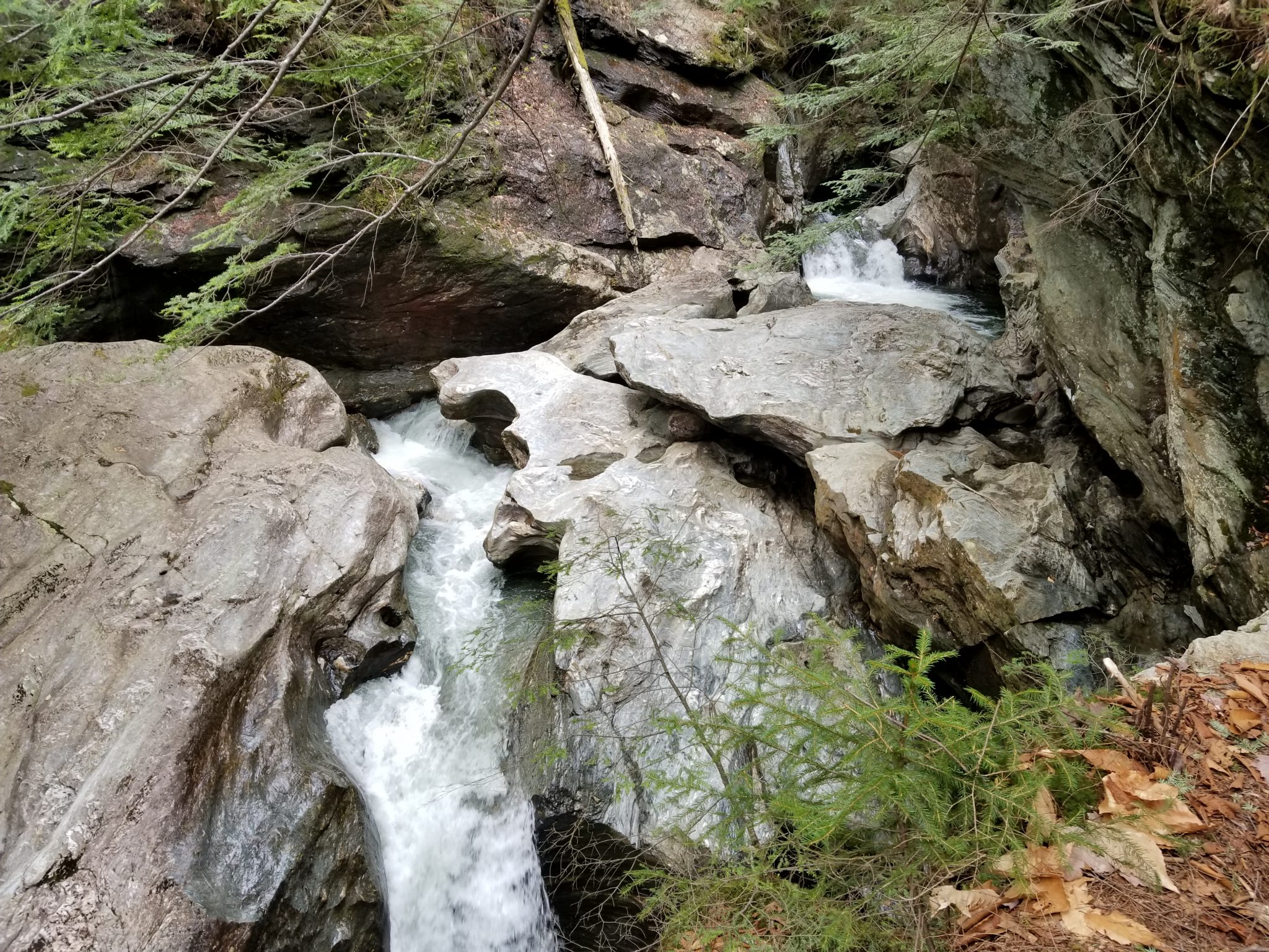
The upper gorge offers incredible views of the winding river which has cut snake-like curves into the giant rockface. There are less fences and rope railings in this section, so be careful as you traverse upriver. As you continue, you will find a small pool of water which looks deceivingly calm. This pool funnels into high speed water vortexes which can be deadly, so hikers should not swim in this area, or any area above the falls.
To reach the falls, head right at the initial trail fork which leads down a skinny stone path, utilizing the stones as steps. These stones are almost always wet and slippery, so take your time and ensure each step you make is secure. Passing other hikers can be difficult in this section, so it is best to allow hikers coming uphill to make it to the top before you begin your descent.
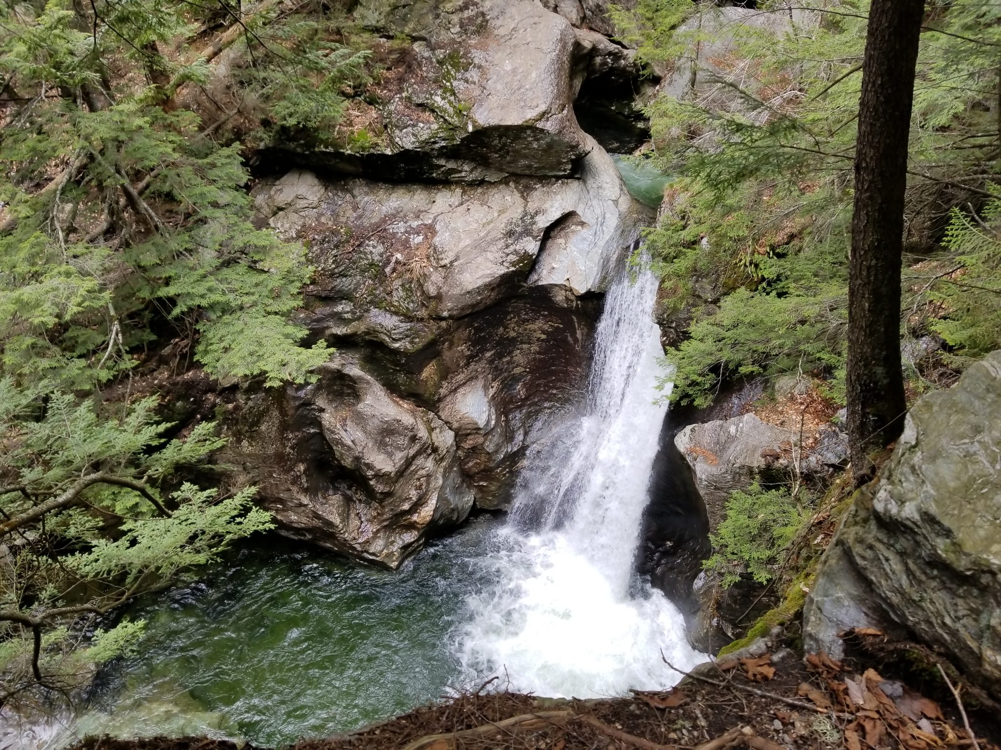
You will soon reach the base of Bingham Falls which offers spectacular views of the 40-foot waterfall and a cool, refreshing mist. Take as many photos as you wish, and when you are ready, begin your ascent back up to the parking area.
Looking for a very different view of Bingham Falls? Check out the Bingham Falls via Mill Trail hike, which traverses the opposite side of the river, providing a spectacular birds-eye view of the falls and upper gorge.
Additional Hiking Resources
Flip through the full Stowe Hiking Guide, download it to your device or continue to browse other local hikes.